

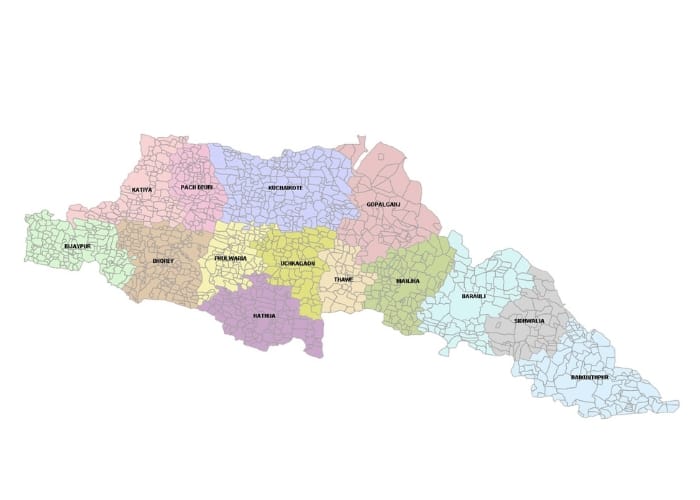
Subdivision and Blocks Gopalganj, Bihar
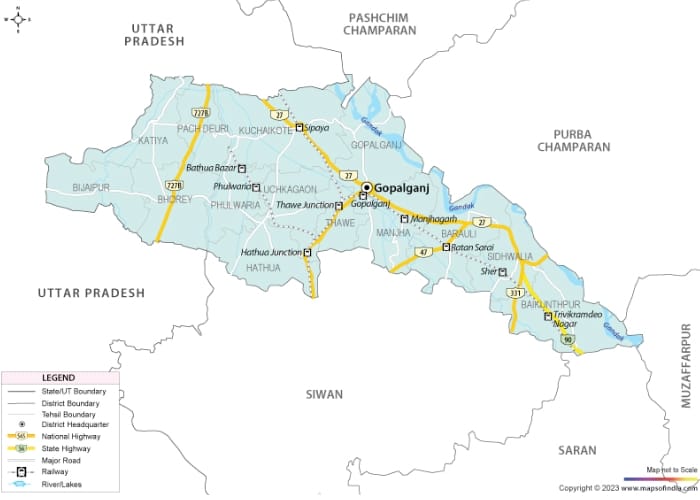
Gopalganj district, located in the Indian state of Bihar, is administratively structured into two subdivisions: Gopalganj and Hathua. Each subdivision comprises seven blocks, Totaling 14 Blocks across the district.
Subdivision and Block Details
Gopalganj Subdivision:
Baikunthpur: This block encompasses 204.11 square kilometers and had a population of 217,165 as per the 2011 Census.
Barauli: Covering 184.38 square kilometers, Barauli had a population of 263,876 in 2011.
Gopalganj: Spanning 195.47 square kilometers, this block’s population was 219,527 according to the 2011 Census.
Kuchaikote: The largest in the subdivision, Kuchaikote covers 251.43 square kilometers and had a population of 332,041 in 2011.
Manjha: This block covers 141.47 square kilometers and had a population of 199,452 as per the 2011 Census.
Thawe: The smallest in the subdivision, Thawe spans 69.99 square kilometers with a population of 116,106 in 2011.
Sidhwaliya: Covering 120.13 square kilometers, Sidhwaliya had a population of 141,563 according to the 2011 Census.
Hathua Subdivision:
Bhorey: This block spans 147.73 square kilometers and had a population of 178,199 in 2011.
Hathua: Covering 146.65 square kilometers, Hathua had a population of 221,804 as per the 2011 Census.
Kateya: This block encompasses 126.17 square kilometers with a population of 130,830 in 2011.
Panchdeori: The smallest in the subdivision, Panchdeori covers 92.82 square kilometers and had a population of 99,933 as per the 2011 Census.
Phulwariya: Spanning 95.56 square kilometers, Phulwariya had a population of 130,801 in 2011.
Uchkagaon: This block covers 113.29 square kilometers and had a population of 177,677 according to the 2011 Census.
Vijayipur: The largest in the subdivision, Vijayipur spans 130.40 square kilometers with a population of 133,038 in 2011.
Administrative Hierarchy
District Collector: At the apex of the district administration, the District Collector oversees governance and implementation of policies across Gopalganj.
Sub-Divisional Magistrates (SDMs): Each subdivision is managed by an SDM responsible for maintaining law and order, as well as coordinating various governmental functions within their jurisdiction.
Circle Officers: These officials head the circles within each block, focusing on revenue collection and local administrative tasks.
Block Development Officers (BDOs): BDOs coordinate development activities at the block level, ensuring the implementation of government schemes and addressing local issues.
Local Governance
Gopalganj District comprises 234 Gram Panchayats, which serve as the grassroots level of democracy, facilitating local self-governance and community development. Additionally, the district includes four urban councils:
Gopalganj Nagar Parishad: An urban council with an area of 11.11 square kilometers and a population of 67,339 as per the 2011 Census.
Kateya Nagar Panchayat: This council covers 12.06 square kilometers and had a population of 20,193 in 2011.
Mirganj Nagar Panchayat: Spanning 5.48 square kilometers, Mirganj had a population of 26,240 according to the 2011 Census.
Barauli Nagar Panchayat: The largest among them, Barauli covers 22.21 square kilometers with a population of 41,877 in 2011.
Demographic Insights
As per the 2011 Census, Gopalganj District had a total population of 2,562,012, with a sex ratio of 1,021 females to 1,000 males, which is higher than the state average of 918. The district’s literacy rate stood at 65.47%, reflecting ongoing efforts to improve education. Notably, there are 169 uninhabited villages out of a total of 1,566 in the district. Dighwa village in Baikunthpur block is the most populated, with 21,100 residents, while Rini Math in Bhorey block is the least populated, housing just one individual. Kuchaikote block contains the highest number of villages (222), whereas Sidhwaliya has the fewest (50).
Conclusion: Gopalganj Subdivision & Blocks
The administrative framework of Gopalganj District is meticulously organized to ensure effective governance and development. With its subdivisions, blocks, and local governance bodies working in tandem, the district strives to meet the needs of its residents and foster progress across various sectors.