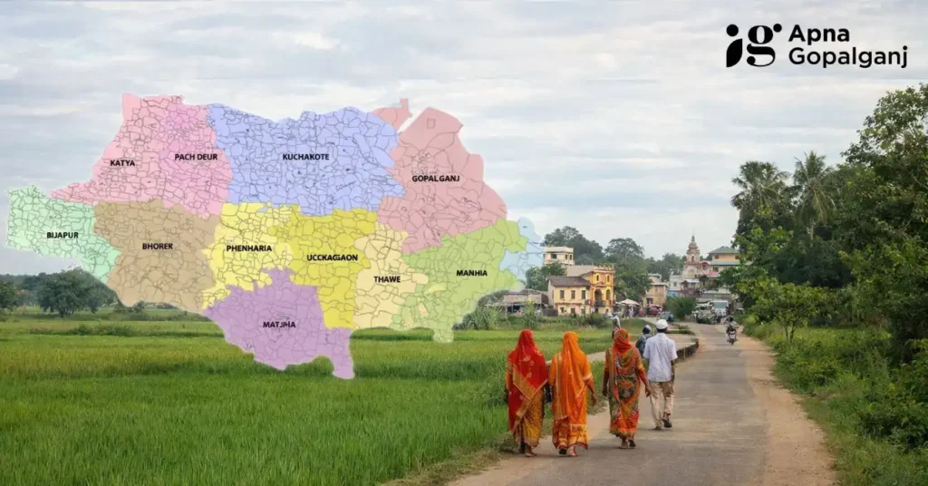
Village and Panchayat Gopalganj: बिहार, भारत का एक ज़िला गोपालगंज, अपने मज़बूत ग्रामीण शासन ढांचे के लिए जाना जाता है, जिसमें 234 ग्राम पंचायतें और 1,566 गाँव शामिल हैं। यह बड़ा नेटवर्क ज़िले के प्रशासनिक और विकासात्मक परिदृश्य में अहम भूमिका निभाता है, यह सुनिश्चित करता है कि शासन और विकास की पहल प्रभावी ढंग से ज़मीनी स्तर तक पहुँचे।
- कुल गाँव (Gopalganj Villages): 234
- कुल पंचायतें (Gopalganj Panchayats): 1566
गोपालगंज प्रशासनिक
यह ज़िला दो सब-डिवीजनों में बंटा हुआ है: हथुआ और गोपालगंज, जिनमें से हर एक में सात ब्लॉक हैं, कुल मिलाकर 14 ब्लॉक हैं। हर ब्लॉक एक प्रशासनिक इकाई के रूप में काम करता है, जिससे सरकारी योजनाओं और कार्यक्रमों को लागू करने में आसानी होती है। ज़िला प्रशासन की कमान ज़िला कलेक्टर के हाथ में होती है, जिन्हें सब-डिवीजन की देखरेख करने वाले सब-डिविजनल मजिस्ट्रेट (SDM) और ब्लॉक के अंदर सर्कल को मैनेज करने वाले सर्कल ऑफिसर सपोर्ट करते हैं। ब्लॉक डेवलपमेंट ऑफिसर (BDO) ब्लॉक लेवल पर गतिविधियों को कोऑर्डिनेट करते हैं, जिससे डेवलपमेंट प्रोजेक्ट्स का काम बिना किसी रुकावट के हो सके।
गोपालगंज जनसांख्यिकी और जनसंख्या
2011 की जनगणना के अनुसार, गोपालगंज जिले में 413,044 घरों में 2,562,012 लोग रहते हैं। आबादी में 1,267,666 पुरुष और 1,294,346 महिलाएं हैं, जिसमें लिंग अनुपात लगभग 1,000 पुरुषों पर 1,021 महिलाएं हैं, जो बिहार के औसत 918 से ज़्यादा है। खास बात यह है कि 0-6 साल के बच्चे कुल आबादी का 17.55% हैं, जो जिले की युवा आबादी को दिखाता है।
गोपालगंज पंचायती राज व्यवस्था
गोपालगंज में पंचायती राज व्यवस्था अपनी 234 ग्राम पंचायतों के ज़रिए स्थानीय स्वशासन को मज़बूत करती है। ये ग्राम पंचायतें स्थानीय विकास, संसाधनों के बंटवारे और कल्याणकारी योजनाओं को लागू करने से जुड़े फैसले लेने में अहम भूमिका निभाती हैं। समुदाय की भागीदारी को बढ़ावा देकर, पंचायती राज व्यवस्था यह सुनिश्चित करती है कि हर गाँव की खास ज़रूरतों और प्राथमिकताओं पर प्रभावी ढंग से ध्यान दिया जाए।
गोपालगंज शहरी केंद्र और नगर पालिकाएँ
हालांकि यह मुख्य रूप से ग्रामीण है, गोपालगंज जिले में चार शहरी केंद्र शामिल हैं:
- गोपालगंज (नगर परिषद): यह ज़िले का मुख्यालय है, जो 11.11 km² में फैला हुआ है और 2011 की जनगणना के अनुसार इसकी आबादी 67,339 थी।
- कटैया (नगर पंचायत): यह कटैया ब्लॉक में स्थित है, जो 12.06 km² में फैला है और इसकी आबादी 20,193 है।
- मीरगंज (नगर पंचायत): यह उंचकागांव ब्लॉक में स्थित है, जो 5.48 km² में फैला है और यहाँ 26,240 लोग रहते हैं।
- बरौली (नगर पंचायत): यह बरौली ब्लॉक का हिस्सा है, यह इलाका 22.21 km² में फैला हुआ है और इसकी आबादी 41,877 है।
ये शहरी केंद्र व्यापार, शिक्षा और स्वास्थ्य सेवा के लिए हब के तौर पर काम करते हैं, जो जिले की ग्रामीण अर्थव्यवस्था को पूरा करते हैं।
उल्लेखनीय गाँव
- सेमरा (Semra): थावे ब्लॉक में स्थित सेमरा अपने एजुकेशनल इंस्टीट्यूशंस के लिए मशहूर है, जिसमें मदरसा इस्लामिया अहसानिया भी शामिल है। इस गांव में रामजानकी और काली मां मंदिरों जैसे महत्वपूर्ण धार्मिक स्थल भी हैं। 5,247 की आबादी वाले सेमरा की साक्षरता दर 76.74% है, जो शिक्षा पर इसके जोर को दिखाता है।
- बंजारी (Banjari More): जिला मुख्यालय के पास एक बड़ा गांव, बंजारी अपनी 76.63% की उच्च साक्षरता दर के लिए जाना जाता है। इस गांव में बंजारी ब्रह्म स्थान मंदिर है, जो एक प्रमुख मंदिर है और भक्तों और पर्यटकों दोनों को आकर्षित करता है। खेती, खासकर धान की खेती, इसकी अर्थव्यवस्था की रीढ़ है।
- सासामुसा बाजार (Sasamusa Market)
- श्यामपुर बाजार (Shyampur Market)
- संग्रामपुर गोपाल, लाइन बाजार (Sangrampur Gopal, Line Bazar)
विकास पहल
ज़िला प्रशासन ने ग्राम पंचायतों के साथ मिलकर इंफ्रास्ट्रक्चर, शिक्षा, स्वास्थ्य सेवा और साफ़-सफ़ाई को बेहतर बनाने के मकसद से कई पहल शुरू की हैं। महिलाओं के सशक्तिकरण, कौशल विकास और गरीबी कम करने पर फोकस करने वाले कार्यक्रम निवासियों के जीवन की गुणवत्ता को बेहतर बनाने के लिए सक्रिय रूप से लागू किए जा रहे हैं। पंचायती राज व्यवस्था स्थानीय ज़रूरतों की पहचान करने और इन कार्यक्रमों को प्रभावी ढंग से लागू करने में महत्वपूर्ण भूमिका निभाती है।
Also Read:
2025 में गोपालगंज जिले की जनसंख्या धर्म के अनुसार
गोपलगंज का पुराना नाम क्या है? जानिए गोपलगंज के इतिहास
निष्कर्ष: Village and Panchayat Gopalganj
गोपालगंज जिले के गांवों और पंचायतों का व्यापक नेटवर्क स्थानीय चुनौतियों से निपटने और विकास को बढ़ावा देने में विकेन्द्रीकृत शासन की ताकत का उदाहरण है। प्रशासनिक निकायों और स्थानीय समुदायों के बीच तालमेल यह सुनिश्चित करता है कि जिला अपनी समृद्ध सांस्कृतिक विरासत और आधुनिक प्रगति के बीच संतुलन बनाते हुए लगातार आगे बढ़ता रहे।